This is a self-grading exam. Answers are entered by selecting the checkbox corresponding to your answer choices(s) or by typing-in your answers in the case of fill-in test items (if applicable). The examination is scored by clicking the 'Grade Test' button at the bottom of the form. Correct answers and explanations are found through hyperlinks at the bottom of the page. This test requires that your browser be JavaScript enabled. Please verify that JavaScript is activated if you encounter any problems. NOTE: Fill-in/Essay test items (if any) cannot be graded and thus are ignored. However, you may view these test items for their correct answers in the 'Correct Answers' section below (if provided by your instructor).
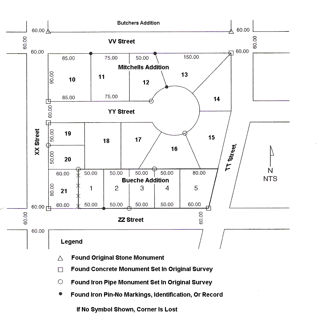
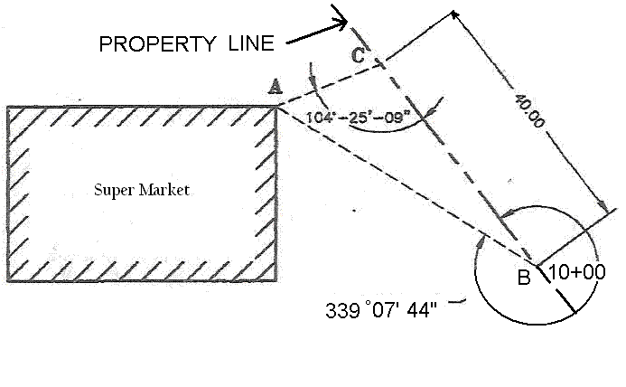
(A) at a proportioned distance on the line described by the iron pipe at the NE corner and the iron pipe at the NW corner of lot 1
(B) at a distance of 80.00 ft measured along a line perpendicular to the north line of ZZ Street from the iron pipe at the SW corner of lot 3
(C) at a distance of 80.00 ft from the iron pipe at the SW corner of lot 3 at a prorated distance between the iron pipes at the NE corner of lot 3 and the NW corner of lot 1
(D) at a distance of 50.00 ft measured along the line from the iron pipe at the NE corner of lot 3 to the iron pipe at the NW corner of lot 1
(A) the friction factor is a variable value based on the impedance of a vehicle traveling around a super elevated curve and is used to calculate the length of the curve
(B) the friction factor is a variable used to increase the extent of the transverse slope of a super elevated curve based on the centripetal force acting on the vehicle traveling around the curve
(C) the friction factor is a variable used to reduce the super elevation of a curve to prevent a vehicle traveling around the curve from skidding inward.
(D) the friction factor is a quantification of the centrifugal force acting on a vehicle traveling around a super elevated curve that is used to calculate the length of the curve
(A) Contact the homeowner before entering and tell them what you will be doing.
(B) Explain to the homeowner that state law permits surveyors to enter lands for the
purpose of using survey monuments without delay the day of the survey.
(C) Contact the homeowner and come to a mutual verbal agreement.
(D) Get written consent from the homeowner prior to entering the property.
2. (471) a surveyor staking a circular are 60 ft long finds that the plans show the curve has a degree of curve of two. The surveyor is about to calculate the length of the radius when the party chief tells him " it is simply 60 times 1 radian." Which of the following relationships correctly describes 1 radian?
3. (472) a property owner over seas gets a hold of a his surveyor with instructions concerning a survey. One of the instructions stated " please be certain that the property has at least 7 hectares." What is a hectare?
4. (552) which of the following terms describes the third party, if a grantor and grantee are the
closing stages of the transfer of real property in which a third party holds a grant that will
be delivered only when all the conditions for the transfer are complete?
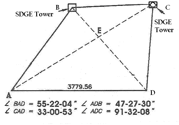
7. (515) occupying point B at the easterly end of a line AB that bears S62°18'34"E, a deflection angle of 00°05'19" is turned to the left to point C. occupying point C, a deflection angle of 00°00'17" is turned to point D. what is the azimuth from north of line CD?
9. (507) a surveyor must stake a symmetrical vertical curve where an entering grade of +0.80% meets an existing grade of -0.40% at station 140+00, which has an elevation of 500.00 ft, the maximum allowable change in grade per 50.00 ft is -0.10%. what is the elevation of 142+00 on the vertical curve?
10. (475) while preparing a PPM (parts per million) on a EDM, you discover that the only chart available is calibrated in degrees Celsius. The thermometer indicates 72° Fahrenheit. What is the corresponding temperature in degrees Celsius?
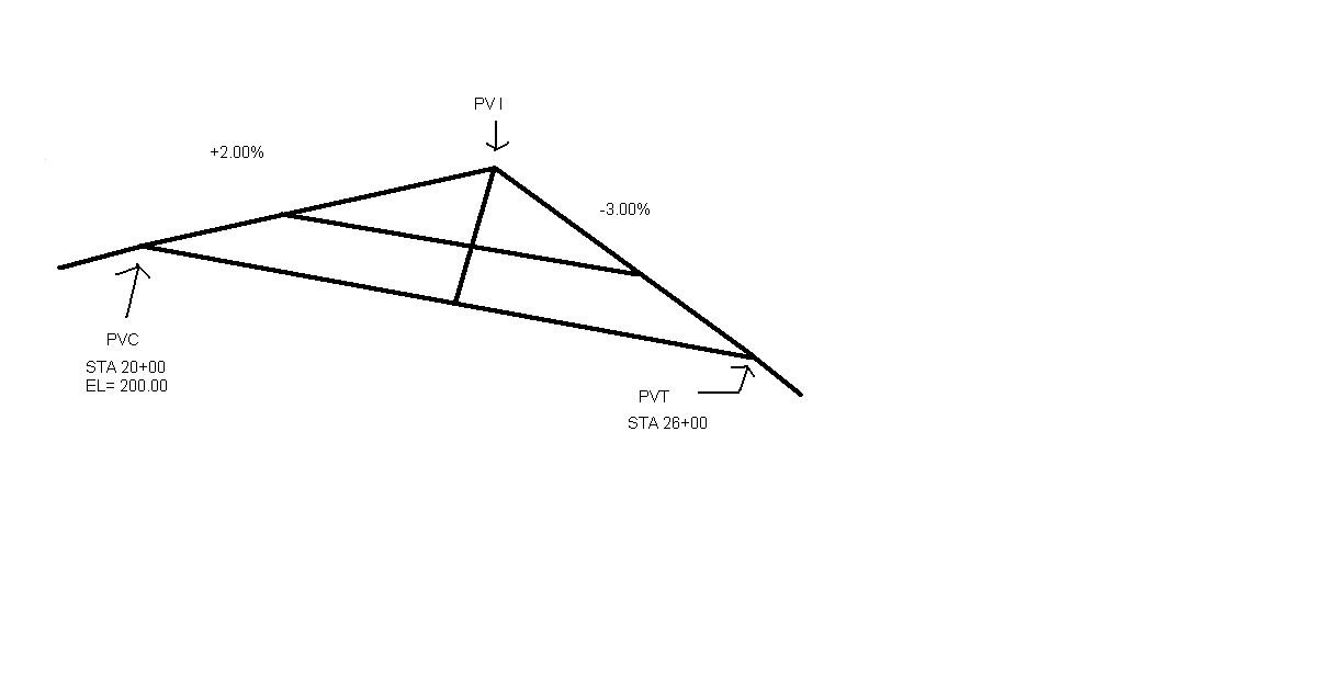
11. (539) A cross-pan drainage structure is to be built on the roadway that follows the asymmetrical vertical curve illustrated. At what station should the pan be constructed?
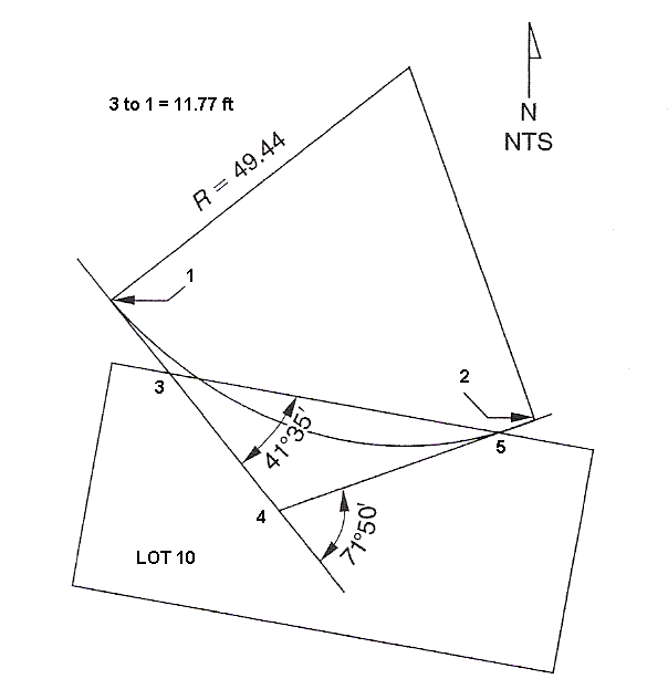
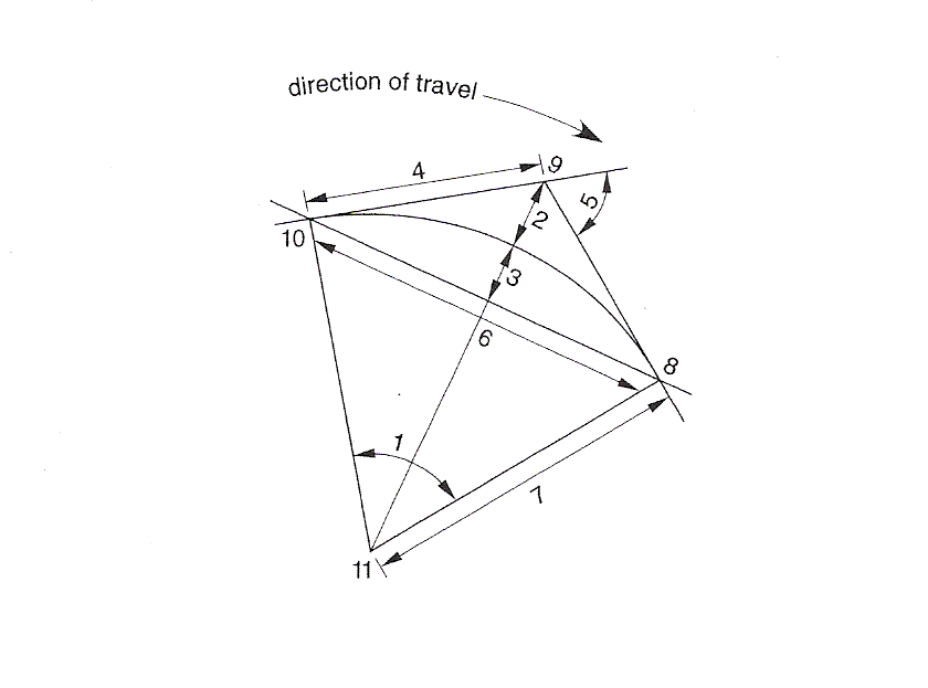
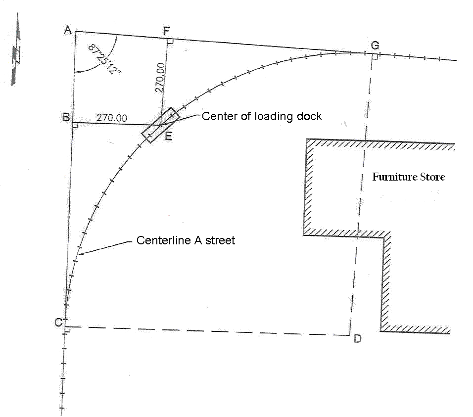
12. (532) The curve shown is the southerly limit of a proposed right-of-way. The encroachment of the curve onto lot 10 is not acceptable, so the curve must be realigned, a compound curve will be constructed, both curves will be tangent to the northern boundary of lot 10. the first curve of the compound curve will begin at point 1, and point 3 will be its PI. What will be the radius of the first curve of the compound curve?
16. (605) what is the term used to describe a monument that sometimes cannot be considered proved or disproved which in such circumstances a monument may be accepted by reputation?
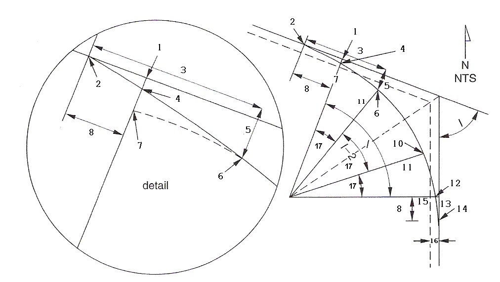
19. (551) Assume that the degree of curve of the circular portion of the arc is 8° and the length of the spiral curve is 583.54 ft. under these condition, what is the spiral angle 17?
22. (542) the meaning friction factor as used in the design of super elevated curves can best be described by which statement?
Answer: (C) the friction factor is a variable used to reduce the super elevation of a curve to prevent a vehicle traveling around the curve from skidding inward.
29. (444) Which of the following is a GIS produced map of topography involving a color
sequence filling the spaces between contour lines and designed to illustrate variation?
32. (368) In order to achieve the best possible horizontal accuracy, which of the following
would be the most important with regard to the electronic distance measuring device used?
Answer: (A) Know the exact atmospheric temperature and pressure.
48. (280) Given the following information what is the low point station of the vertical curve.
G1 -2.0,G2 5.0, Beg Station 12+00, Beg El 259.63, VC length 650.00
50. (263) If vertical photography is taken at a negative scale of 1:15,000, what would most nearly be the expected measurement on the photograph between to adjacent section corners?
51. (261) With a zenith angle of 96ş37'25" what is the difference in elevation assuming both instrument and rod are the same Height at a distance of 87.39 feet.
53. (54) The azimuth from a point to a reference mark is 95°33'10" as measured from astronomic north. If the La Place convergence is disregarded and the convergence is +0°26'42", what is the state plane coordinate grid azimuth to the reference mark?
55. (98) what is the grade of a section of highway that has a centerline elevation of 347.50 at station 45+40.00 and a centerline elevation 489.20 ft at a station of 63+87.40?
57. (234) The perimeter of a circle is 110 ft. You plan to put a fence around this circle with posts that are ten feet apart. How many fence posts are needed to complete this task
60. (146) ) If vertical photography is taken at a negative scale of 1:15,000, what would most nearly be the expected measurement on the photograph between to adjacent section corners?
64. (229) In what order should the following list appear for describing a piece of land.
a) Lot or Parcel
b) Block
c) Tract
d) City
e) County or Parish
f) State
g) Map Recorded ( Book and Page)
h) Public Office
68. (57) If the bearing of a tangent entering a highway curve to the right is N62°E and the interior angle of the curve is 19° what is the bearing of the tangent out of the curve?
69. (208) Between two private owners of sequential conveyances, which of the following would most likely control if their deeds contain conflicting elements?
74. (85) assuming a straight segment of road centerline, what is the horizontal distance between a point on the right of way of a road located at station 132+42 with an offset of 24.36 ft right and a point located at station 150.41 with an offset of 48.17 ft left?
76. (64) What is the azimuth and distance (in the same units as the coordinates) between point 1 and point 2 having the following Cartesian coordinates?
Point X coordinates Y coordinates
1 5000 5000
2 6247 3797
78. (99) a 1500 foot-long earthen berm has a cross section with an area of 3000 ft sq at one end and 3500 ft sq at the other end, with area increasing at a constant rate, what is the approximate volume of material in the berm?
79. (38) The field measurements at the point of beginning on a closed traverse are N 5000.00 and E 8000.00; the calculated coordinates at the same point are N 5000.673 and
E 7999.363 what is the linear error of closure of the traverse?